
Data Centers and Land Use in Montgomery County
Is a hyperscale data center coming to your neighborhood? Potentially.
Hyperscale Data Centers and Data Center campuses greatly exceed 100,000 square feet and the largest are more than a million square feet in size (equivalent to 20 football fields or enough space for 100 homes!). They are built and operated by companies like Google, Amazon, Microsoft, and Facebook (Meta) to support massive cloud computing, AI, and internet services.
-
Large and hyperscale data centers take up many acres of land, require access to transmission lines, fiber optic cable, and large amounts of water for cooling, and will require massive new electrical supply and supply lines.
-
ZTA 26-01 would allow large data centers in all industrially zoned areas – in every part of the County.
There are more questions than answers
ZTA 26-01 would allow data centers in any zone classified as serving light, medium, and heavy industry.
While there are few individual parcels in the County large enough to house a large data center, properties could be acquired and consolidated into a larger footprint to accommodate data centers.
Industrial sites tend to be located in underserved/overburdened communities and many of them lie in our planned growth corridor, some near metro stations.
No analysis has been provided to the public as to the distance of industrial parcels or industrial zones from our schools, homes, hospitals, and sensitive ecological areas, or how this use is compatible with our land use sector plans and master plans.
The climate is getting hotter. So are our neighborhoods. Data centers contribute to the urban heat island by warming the land around them - an average of about 4 F. Extreme cases have been documented increases up to 16 F.
Where are Montgomery County’s industrial zones?
Almost every council district has one or more areas suitable for a data center complex, especially:
-
Council District 1 - Council member Friedson,
-
Council District 2 - Council member Balcombe,
-
Council District 3 - Council member Katz,
-
Council District 7 - Council member Luedtke.
How could a data center affect my neighborhood?
Data centers generate noise, vibration, air and water pollution, and contribute to the urban heat island, as well as carbon pollution driving climate change.
ZTA 26-01 states that there must be a 500-foot setback from schools, homes, and hospitals, but experience in other jurisdictions suggest that setbacks should be upwards of 1,500 feet to avoid noise, vibration, air pollution, and other impacts to neighbors.
Massive data centers in Northern Virginia have resulted in urban and agricultural areas that have become vacant of anything except data centers as property owners sell out to the highest bidder, and whole areas are rezoned for this use. Some have been built adjacent to existing residential areas with no setbacks.

Tractor trailer-size generators are visible next to a data center along the W&OD Trail in Loudoun County, VA. (Hugh Kenny, Bay Journal)
So, where exactly are these zones in our County?

Find your Council District using this link that takes you to the County's website.
List of Council members and their contact information is available here on the County's website.
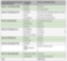
District 1 - Council member Friedson
Area near Travilah Elementary School and Serpentine Barrens Conservation Park

District 1 - Council member Friedson
Area near Westland Middle School, Washington Episcopal School, Westbrook Elementary School

District 2 - Council member Balcombe
Area near Potomac River and Dickerson Conservation Park

District 2 - Council member Balcombe
Area near Germantown

District 3 - Council member Katz
Area near Derwood and Montgomery College

District 4 - Council member Stewart
Area near Rock Creek and Chevy Chase

District 4 - Council member Stewart
Area near Forest Glen (closeup) - Montgomery Hills Junior High School

District 5 - Council member Mink
Area near Fairland

District 6 - Council member Fani-González
Area in Rockville / North Bethesda

District 7 - Council member Luedtke
Area near Montgomery Village and Flower Hill (equity overlay)

District 7 - Council member Luedtke
Area near Montgomery Village and Flower Hill

District 7 - Council member Luedtke (adjacent to District 3 - Katz)
Area near Montgomery College and Derwood
